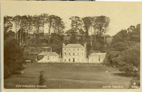
Coytrahen House To read the history of Coytrahen House published by coflein.gov.uk please click here |
Llangynwyd Lower Community Council Cyngor Cymuned Isaf Llangynwyd
Date of Next Meetings Wednesday 29th October, 2025 7.00p.m. Meeting Room Philip Squire Community Hall Coytrahen, CF32 0EB |
Meetings of the Llangynwyd Lower Community Council Cyngor Cymuned Isaf Llangynwyd
are held on the last Wednesday of the month no meeting are held in the months of July and December
Llangynwyd Lower Community Council Cynfgor Cymuned Isaf Llangynwyd The Community of Llangynwyd Lower Community Council lies within the boundaries of the County Borough of Bridgend. The Llangynwyd Lower Community is North of Junction 36 on the M4 corridor, it is the most southerly of the Llangynwyd parishes with Llangynwyd Middle and Llangynwyd Higher Maesteg to its northern side. The largest settlement of Llangynwyd Lower Community Council area today is located in the village of Coytrahen which is on the main Bridgend to Maesteg road the A4063 and sits on the banks of the river Llynfi, with farms and scattered houses to the western boundary. The river Llynfi rises in the hills above Maesteg and flows down to Aberkenfig wre it joins the river Ogmore on it way to the Atlantic Ocean at Ogmore-by-Sea. To the east of the village of Coytrahen runs the Bridgend to Maesteg passenger railway, the nearest railway is at Tondu just some two mile away, the line was built mainly for the transportation of minerals which saved it from closure in 1963 when Beeching cut so many rural railway lines in the United Kingdom. The Llangynwyd Lower Community Council is one of the smallest communities in the Bridgend County Borough area by population alone which was recorded in 2001 as being 467, the area of Llangynwyd Lower Community Council is rural and covers a larger geographical area that the higher populated communities within the borough. The first census record of the parish of Llangynwyd Lower records the parish being in the ecclesiastical parish of St. Cynwyd's Llangynwyd but by 1911 the ecclesiastical parish had been changed to St. John's, Aberkenfig. The first census record of the parish of Llangynwyd Lower was taken in 1841 the parish was then made up mainly of Farms and largest settlement being the hamlet of Pontrhydydu which now stand in ruin. The population of Llangynwyd Lower in 1841 was just 165 and the terraced cottages in Coytrahen were yet to be built. In 1841 the census records for Llangynwyd Lower records the parish being in the ecclesiastical parish of St. Cynwyd's, Llangynwyd but by the 1911 the ecclesiastical parish had been changed to St. John's, Aberkenfig. The village of Coytrahen had for many years' two places of worship St. Thomas Church and the Wesleyan Chapel. Has congregations fell both were sold and are now private dwellings. Coytrahen House was built by John Popkin to the east side of Coytrahen village and laid in the parish of Bettws but boundary changes puts it now into Llangywnyd Lower whilst Tondu House stood to the western side. Tondu House played an important roll in World War II but unfortunately fell into disrepair after the War. The estates of Coytrahen and Merthyr Mawr still own large parcels of land in the Llangynwyd lower community area. Coytrahen House and Tondu House are recorded as lost houses of Wales, only one wing of Coytrahen survives and Tondu House unfortunately is totally in ruin other than its farm buildings. |
At the last General Election Llangwynd Lower moved from the Ogmore Constituency for UK Parliament representation to the newly formed Constituency of Bridgend & Porthcawl but remains in the Constituency of Ogmore for the Welsh Assembly Below please find contact information for your Member of Parliament - Welsh Assembly and County Borough below
|


